USGS banner.
 
A photo of aggradation of a large gravel bar in a river.

Go to the references cited page. Go to the references cited page. Go to the references cited page. Go to the index map page. Go to the index map page. Go to the index map page. Go to the bank-condition categories page. Go to the bank-condition categories page. Go to the bank-condition categories page. Go to the bank assessment page. Go to the bank assessment page. Go to the bank assessment page. Go to the study methods page. Go to the study methods page. Go to the study methods page. Go to the study objective page. Go to the study objective page. Go to the study objective page. Go to the background page. Go to the background page. Go to the background page. Go to the introduction page. Go to the introduction page. Go to the introduction page. Site navigation side bar.


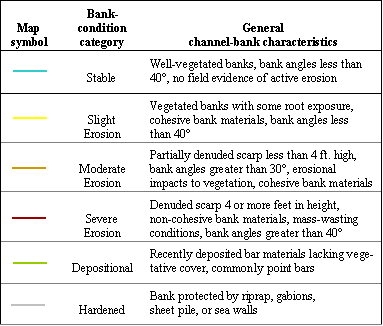
Channel-Bank Conditions and Accumulations of Large Woody Debris along White River between Anderson and Indianapolis, Indiana, 2002

Bank-Condition Categories

The table below provides a list of the descriptive bank-condition categories used in the mapping process and a general description of the bank characteristics that were observed and evaluated to assign each bank segment to one of the bank-condition categories.

Explanation of map symbols.

In this investigation, a total of 124.9 miles of channel bank were evaluated and assigned to one of the six bank-condition categories listed above. Of these 124.9 miles, 53.6 miles (43 percent) were mapped into the slight-erosion category, 50.4 miles (40 percent) were mapped as stable, 9.3 miles (7 percent) were mapped into the moderate-erosion category, 4.6 miles (4 percent) were mapped as hardened, 4.2 miles (3 percent) were mapped as depositional, and 2.8 miles (2 percent) were mapped as showing signs of severe erosion.


<<<Previous Page        Next Page>>>


U.S. Department of the Interior
U.S. Geological Survey
5957 Lakeside Boulevard
Indianapolis, Indiana
46278-1996
USA
Phone: (317)290-3333
Fax: (317)290-3313
URL: http://in.water.usgs.gov/newreports/bankerosion/page6.shtml
Last modified:Tuesday, 15-Jan-2013 13:25:36 EST
E-mail questions and comments to webmaster

[Go Home] USGS Indiana Home Page